
History
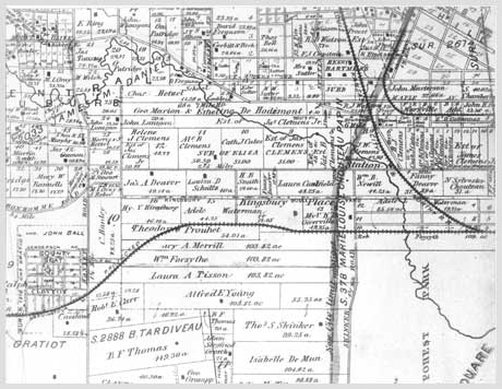
An 1878 map of the area west and north of Forest Park. --From "Urban Oasis - 75 years in Parkview a St. Louis Private Place"
From Farmland, Planners and their Plan
The land beneath Parkview was a part of a 1796 Spanish land grant of some 2,700 acres to Maria Louise Chouteau Papin, whose brother, Auguste Chouteau, was one of the co-founders of St. Louis. On this vast parcel on the banks of the River des Peres and extending from Maple Ave on the north to Art Hill on the south, and from Union Blvd on the east to Jackson Ave on the west, Madame Papin realized her dream of a farm. Well into the 1800s, descendants of the extended Chouteau-Papin family still owned a significant portion of the property, by then called Kingsbury Farm, bounded by Union to a point about a mile and a half west of Skinker and from the center of Delmar south to the Wabash railroad tracks where now lies Forest Park Parkway (aka Millbrook).
As the end of the 19th century neared, St. Louis had expanded west to the doorsteps of Kingsbury Farm. On its southeastern edge a huge city park had been developed, which was dedicated in 1876 as Forest Park. Concurrent with Forest Park's dedication, the City-County boundary was established just beyond the park's western edge, taking the larger part of Kingsbury Farm into the county. To the north and to the east there was considerable residential building, including several fine private neighborhoods just east of DeBaliviere. In 1895 Robert S. Brookings chose land just south of Kingsbury Farm and west of Forest Park as the new home of Washington University. Kingsbury Farm had not yet garnered the same eager interest by prospective owners and businessmen, no doubt largely due to the meandering course of the River Des Peres through the property. With higher ground to the west, heavy rains routinely caused the River des Peres to overflow its banks. What was to become Parkview was part of a natural flood plain.

View west down Lindell from deBaliviere, April 7, 1902. The sign says "Private Street No Hauling Permitted". Washington University's Brookings Hall is in the distance. --Photo in the private collection of E. Taylor; reproduced with permission.
Then came plans for the Louisiana Purchase Exposition in St. Louis, and the prospect that the fair might be sited in the undeveloped western portion of Forest Park. The surrounding areas of open farmland were furiously scrutinized by businessmen who visualized the profits that could be theirs if they could develop it to handle the crowds that would be attending the fair. Seizing on this prospect, early in 1901 Courtland B. Van Sickler bought an interest in the parcels of land bounded by DeBaliviere, Skinker, Delmar and Forest Park, abutting the eastern edge of where Parkview would eventually be. Mr. Van Sickler is listed in the 1903 Gould’s Saint Louis Directory as a clerk in a dry goods store, and it seems plausible that he may have represented a group of wealthy investors. It was a portentous acquisition. In June of 1901, the Louisiana Purchase Exposition Committee announced that the Exposition would be built on the western half of forest Park and other land to the west, which would be leased from its owners (e.g., Washington University). Within five months, by November 1901, The Parkview Realty and Improvement Company was formed with a capital stock of $5.5 million, an enormous sum for the time. Van Sickler was far and away the majority stockholder, holding more than 45,000 of the 50,000 shares. The land area acquired by Parkview Reality and Improvement was that between DeBaliviere, Skinker, Delmar and Forest Park (the land purchased earlier in the same year by van Sickler) plus an additional 80 acres just west of Skinker - the eventual home of Parkview.

Grading gang at work June 12, 1902. --Photo in the private collection of E. Taylor; reproduced with permission.
Many established St. Lousians were involved in Parkview Realty and Improvement Company. Henry S. Caulfield, attorney for the Lincoln Trust Company, soon to be one of the original trustees of Parkview, and later governor of Missouri, filed the Articles of Incorporation. Corporate directors were Adrian Ogle Rule, vice president of Kilgen-Rule Real Estate Company; Thomas Wright, a cigar manufacturer; Moses Greenwood, Jr., a U. S. Assistant Civil Engineer; George Durant, general manager of Bell Telephone and first vice-president of Lincoln Trust Company; and Edward H. Coffin, who worked for the Wabash Railroad. Early in 1902 the company hired well-regarded railroad builder John Scott to grade the land and tame the River Des Peres. The labors of man and beast took nearly two years to complete, being finally finished in December 1903 at a cost of nearly three quarters of a million dollars and a year behind schedule. The exorbitance of the cost provoked a lawsuit against Scott that worked its way through the courts for ten years and ultimately went to the Missouri Supreme Court.

From the 1903 prospectus of the Parkview Realty and Improvement Co. --From "Urban Oasis - 75 years in Parkview a St. Louis Private Place"
While the grading work dragged on, the owners of Parkview Realty and Improvement Company refined their plans. They divided their property into three sections and had plans for each both during and after the World's Fair. One section was the Catlin Tract, the long narrow strip of land immediately bordering the northern edge of Forest Park along Lindell. This was leased to the Exposition and was used as the World's Fair amusement center. After the fair, the Catlin Tract became the private neighborhood of gracious homes on Lindell Blvd. facing Forest Park that we see today. Section two encompassed the remaining property north of the Catlin Tract to Delmar. This was leased for storage and construction of temporary hotels, cottages, restaurants and the like to serve the Fair. After the fair, this area stood mostly vacant for some years despite Parkview Realty and Improvement's initial hopes that it would develop immediately into sites of high class apartment buildings and residences. The third section was the 80 acres just on the other side of Skinker, between Skinker and Melville, the railroad tracks and Delmar. This was considered the most ideal and desirable of the tracts. Plans were to sell the interest in this land to an association of members of the Parkview Realty and Improvement Company and friends who would form a separate real estate company to develop and sell lots in a high-class private residential neighborhood. Thus was formed Beredith Realty.
Parkview takes form

The little office on the corner of Skinker and Delmar from which lots in Parkview were sold by McCormick-Kilgen-Rule. --From the Parkview archives.
Beredith Realty's Articles of Association lists 26 investors, several of whom had a particular relation to Parkview. Thomas Wright was an original director of Parkview Realty and Improvement Company. A. A. B. Woerhelde was President of Lincoln Trust Company when Parkview Realty was incorporated; George W. Lubke was second vice-president and J. H. August Meyer was third vice-president. Woerhelde became president of Beredith Realty and Meyer was assistant secretary. R. F. Kilgen and his partner, Adrian O. Rule, ran McCormick-Kilgen-Rule, which handled sales of Parkview lots out of their small office on the corner of Skinker and Delmar. Adrian Rule also became one of the three original Parkview Trustees. Architect William A. Swasey was hired by Beredith Realty to work on about a dozen speculative houses in Parkview but left town before he could fulfill his assignment. Murray Carleton was president of the dry goods store where Courtland Van Sickler was listed as a clerk. John C. Roberts also became one of the original Parkview Trustees. Noted finally is investor Julius Pitzman, renowned surveyor, civil engineer and city planner who shaped and molded Parkview from a barren parcel of farm land into the last and largest private place he would design in the St. Louis area.

Julius Pitzman survey of a lot in Parkview purchased by Jesse and Sarah Ambler, signed by Pitzman March 27, 1909. --From the Ambler collection in the Parkview Archives.
Julius Pitzman, born in 1837 in Halberstadt, Germany, came to St. Louis in 1854, where he worked for his brother-in-law, Charles E. Salomon, who was the county surveyor. By 1856, Pitzman was appointed city surveyor. He started his own business in 1859 - Pitzman's Co., Surveyors and Engineers. Pitzman made a name for himself in St. Louis and was chief topographical engineer for the Union forces under General Sherman during the Civil War. He introduced, if not originated, the concept of the private place - selling residential lots under deed restrictions which limited them to single family occupancy and made lot holders also owners of their streets, alleys, etc. He designed his first private street, Benton Place at Lafayette Park, in 1867, drawing on the earlier experiences of Lucas Place downtown, and thereafter laid out most all the private places in St. Louis, which has more of them than any other American city. He studied park systems in Europe preparatory to laying out Forest Park, one of the largest municipal parks in the country. Even as he was designing Parkview he was also working on major St. Louis riverfront improvements. His prestige extended outside St. Louis; he designed a city park in Little Rock, Arkansas, a race course in Nashville, Tennessee and the Industrial suburb Granite City, Illinois.

Pitzman's Parkview design. Dark green areas are the neighborhood's parks. --Digital map © C. Kirmaier 2004, reproduced with permission
Parkview and Forest Park share the similarities of being sited on rectangular tracts of land with streets laid out in curvilinear patterns. Using the "norm" for street patterns - north to south, east to west - would have produced more saleable street frontage in Parkview. Instead, Pitzman chose to provide more green spaces and curving streets more soothing and peaceful to the eye. The flow added privacy and diminished the monotony of the uniform building setbacks as the streets curved gently out of sight. The northwest and southwest corners of Parkview, bypassed by the curving streets, were given over to triangular parks that intensified the green environment envisioned as planners planted closely-spaced street trees. Trees were also planted around the perimeters of the parks to define and enclose them. A smaller semi-circular area off Skinker originally for sale went unsold and ownership was neglected for decades. It became part of the neighborhood's common property in the early 1980s when the homeowner across the street spied the property listed as one the City was about to auction off for back taxes. The neighborhood's Agents (Trustees) quickly paid the taxes due thereby solidifying its place for all time as the third of Parkview's parks. Pitzman had to contend with Center Street in his design. This pre-existing straight east-west street bisected Parkview and was a major farm-to-market route. Was a truck route to be permitted to run through the middle of a private, single-family subdivision? Pitzman alleviated the problem by reducing Center Street to an alley soon causing farmers to bypass the area altogether.

Looking southeast ca. 1906-07 at the intersection of Center St with Westgate and Waterman, and Center's termination on the western edge of Parkview at the street car line. Westgate Ave continues diagonally to the right to the distant curve around Pershing Park. Washington Univ. is just beyond. Parkview may have been a very different place, or never existed, had a scheme to build a bullfighting ring in this very area where Westgate, Waterman and Center meet come to fruition. The origin of this proposal is not clear, possibly a "wild idea" for the World's Fair. Urban legend further has it that the prospect was instrumental in U. City's passing of an ordinance banning bullfighting and bear-baiting shortly after its incorporation. ---Photo from the Archives of the University City Public Library, reproduced with permission. Visit the Library's website to see other historic Univ. City photos.
Henry Caulfield, who had filed the plat design in November, 1905, as attorney for Beredith Realty Company, in 1906 filed for a trust indenture. He was then a U. S. Representative (and later Governor of Missouri) and was soon to become a Parkview homeowner and trustee until his death in 1960. The trust indenture defined the rights and responsibilities of the homeowners and trustees alike. It named three Trustees -- Henry S. Caulfield, John C. Roberts and Adrian Rule -- and gave them the power to act on behalf on the Parkview residents. It provided the Trustees with an easement over all the public areas in Parkview including the streets, walks, parks and alleys. The Trustees would handle other needed provisions such as security and street lights and were given the authority to collect assessments provided by the Indenture. The annual assessment was mandatory, which acted as a safeguard against non-contributors and further strengthened the organization's permanence. The indenture assured lot owners the use of the street, sidewalks, etc. It also repeated the specifications of the subdivision plat, including widths of streets and alleys, sizes of lots, setbacks, minimum construction costs and zoning differentiation. Lots were to range from $2,000 to $5,000 in cost and the minimum cost of construction was to range between $4,000 and $7,000. The building setback was to be a uniform 50 feet. Construction materials were to be brick, stone or stucco; years proved brick to be the majority choice by far. With streets, sidewalks, curbs, sewers, water mains and electrical lines all in place, construction began.
A glimpse of the first owners and their homes
With the arrival of June 1906 the first building permits were issued. Construction on twelve houses was begun that year nearly all of which are visible in the above photo from The Siege of University City, a book defending University City's controversial founder E.G. Lewis and his projects. Eight houses appeared in a cluster in the 6200 block of Waterman (grouping in the upper right); one house on McPherson (near the photo's upper center) also was in the City of St. Louis. The three other houses were spread out on Washington - one near Skinker and two across from Washington Park. The latter two houses, clearly visible on the left side of the photo, were the first two houses in Parkview built outside the City Limits, seemingly as assurance to buyers in this barren field that development would occur as promised throughout the tract.

Looking east into Parkview late 1906 or early '07. Westgate is in the foreground meeting Center and Waterman on the right.

Seven of the first eight houses on Waterman begun in 1906. The street in the foreground is Berlin, later renamed Pershing. --From the Archives of the University City Public Library, reproduced with permission. Visit the Library's website to see other historic Univ. City photos.
Of those first eight houses on Waterman, four were built by McCormick-Kilgen-Rule on speculation. All four were in the Colonial Revival style. The three houses on Washington probably were also "spec" houses. But at least four of the homes begun in 1906 were commissioned by owners who intended to become long-term residents. The following year, 1907, saw only eight new houses under construction, two more on Waterman, two on Westminster and four on McPherson, all but one within the limits of the City of St. Louis. University City had been incorporated in September of 1906 including in its boundaries the county portion of Parkview. Beredith Reality fought this incorporation in court and lost. Uncertainty over the future of Parkview or University City, and perhaps the financial "panic" of that year undoubtedly affected people's willingness to build homes in Parkview. At the end of 1907, two years after its plat had been filed, Parkview consisted of only twenty houses standing awkwardly among a scattering of spindly saplings on a stubbly plain.

Jesse H. Ambler stands on his newly purchased vacant lot at the corner of Washington and Center in the spring of 1909. Jesse and Sarah Ambler were recent St. Louis transplants from Pittsburgh. The home they built remained in their family for over 80 years, passing to their son who raised a family and lived in the house until his death in 1993. --From the Ambler collection in the Parkview Archives.
The next two years, 1908 and 1909, saw a tremendous spurt of activity, with 71 houses underway. Whereas the earlier houses were mostly Colonial Revival or Tudor Revival in style, the majority of new houses had clear Arts and Crafts stylistic influence on both the exterior and interior. In 1908 alone, more than a dozen houses on Washington were built as Parkview versions of the Arts and Crafts house, distinguished by the skillful and beautiful brick and carpentry work of St. Louis craftsmen and, owing to relatively narrow lots, a taller and more compact form.
By 1914, about 85% of Parkview's 255 houses had been completed. The range of lot sizes and construction prices required by the indenture was producing varying house sizes and some economic diversity among the homeowners. The wide variety of architectural styles and details added visual diversity to the character of the neighborhood. But Pitzman's brilliant design, requiring uniform setbacks to establish order and introducing grace with the form of the gently curving streets, smoothly accommodated the diversity of its parts. As it developed, the subdivision became recognizable as a unique entity within its larger urban context, called by many who know it an urban oasis. This rich texture was particularly noted in 1986 when Parkview was listed on the National Register of Historic Places.
Over the last century, Parkview has been home to people with local, state, national and international reputations in science, politics, sports, business, the professions and the arts. And while the world has changed, Parkview retains its integrity and gives to all who experience it a sense of place.

A Pershing resident circa 1923.
--From the Parkview archives.
If you've enjoyed this snippet of Parkview's history and want to read more along side many more historic photographs taken over the years from 1905 to 2005, we have just your ticket - Parkview: A St. Louis Urban Oasis 1905 - 2005. The product of a dedicated group of Parkview neighbors, this commemorative book updates and expands Parkview's 75th anniversary book, now out of print. The book is available at many local bookstores. If you cannot locate a source please just send an email to the Parkview webmaster, or contact the book's publisher - Virginia Publishing located in St. Louis (City) on Delmar.
Even though our Centennial book has already been published, we continue to look for old pictures of interest taken in Parkview. Please email if you have interesting or unique pictures of homes or people or events that record a time in Parkview. Pictures will be scanned in and promptly returned to you.